


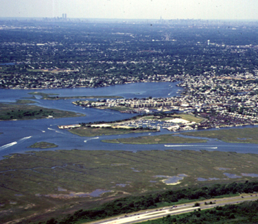
The shoreline of the Western Bays region of the
South Shore Estuary Reserve is highly developed and modified
The South Shore Estuary Reserve comprises the string of shallow bays, and their watersheds, found along Long Island’s South Shore, from Hempstead Bay on the west to Shinnecock Bay on the east. Within the Reserve, the Western Bays subregion includes Hempstead Bay, South Oyster Bay and the lands that drain into them. These bays have unique environmental features not found in waters to the east and they have witnessed more extensive shorefront development and disturbance than other regions of the Reserve. For years, concern has been building about high nutrient levels in the waters of the Western Bays and the relationship of excess nutrients to a blight of Ulva, or sea lettuce, a submerged macroalga that carpets large areas of the bay floor in the region. With support from the NYS Department of State’s Division of Coastal Resources, a team of SoMAS scientists has initiated a two-year study to examine these issues and to make recommendations that will contribute to the formulation of TotalMaximum Daily Load (TMDL) limits for discharges into the Western Bays.
Unlike bays to the east, which are primarily open water, the Western Bays contain large areas of both open shallows and salt marsh islands in a complex interconnected by channels and tidal creeks. Almost all of the mainland shoreline was bulkheaded in the 1950s and 60s as thousands of acres of tidal wetlands were filled to create new home sites. Virtually all mainland tidal wetlands were eliminated by this filling. As a result of disease and water quality problems, significant losses of submerged aquatic vegetation (eelgrass) beds have also occurred in the Western Bays. Habitat loss and water quality problems have had a negative impact on most of the estuarine species in the region. Recreational finfish species have declined, as have shellfish populations, which are also impaired by low rates of recruitment. Elevated levels of coliform bacteria are responsible for the permanent closure of more than 15,000 acres of shellfish beds in the Western Bays, along with periodic closures of bathing beaches.
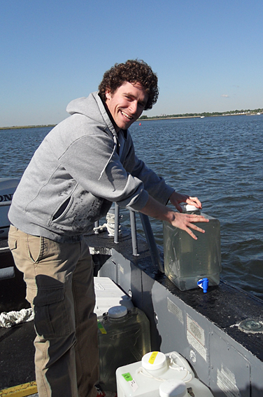
SoMAS graduate student Ryan Wallace
collecting water samples in Hempstead Bay
The SSER Comprehensive Management Plan identifies stormwater runoff from the highly developed watershed as the most significant source of pollution to the Western Bays. Human waste discharges from vessels, excrement from waterfowl and discharges from municipal wastewater treatment plants are also contributing sources. Nutrients from these sources promote the growth of extensive mats of Ulva that are, in part, responsible for the loss of natural seagrass beds in the area. The Western Bays are on the list of impaired water bodies in New York State for both nutrients and pathogens.
The SoMAS team will document the location and extent of water quality and environmental impairments in the Western Bays, wherever possible tying impaired areas to specific pollution sources. Components of the project include:
- review and assess historic water quality data from the region
- employ state-of-the-art SONAR technology to improve understanding of water movement in the Western Bays, as well as the distribution of bottom sediment type and benthic habitats
- conduct water column surveys to document spatial and temporal patterns of physio-chemical properties and the variability of Ulva populations
- determine the distribution of sewage-derived contaminants, oxygen-demanding organic matter and pathogen indicators in the sediments of the Western Bays
- estimate the rate of marsh subsidence in the region as a consequence of potable water withdrawals from underlying groundwater
- assess the likely impact of contaminants and water quality impairments on the fish community in the Western Bays, based on the health of the winter flounder population
The SoMAS team is headed by Associate Dean for Marine Sciences, Dr. Larry Swanson. Other team members include Dr. Anne McElroy, Dr. Bruce Brownawell, Dr. Robert Wilson, Dr. Roger Flood, Dr. J. Kirk Cochran, Dr. Henry Bokuniewicz and Dr. Christopher Gobler, Dr. Charles Flagg and Dr. Michael Frisk.
The plight of the SSER Western Bays has aroused considerable public and management interest, and this interest has been building for several years. The Western Bays Collaborative Working Group, made up of state and local officials and environmental groups, has pushed hard for state funding for the present study, as well as other work being done in the Western Bays by the U.S. Geological Survey and Battelle. Says Maureen Dolan Murphy of Citizens Campaign for the Environment, “This is the first comprehensive science-based research in the Western Bays…and is the beginning step in developing a much-needed and much-awaited restoration plan for these bays. We are thrilled that SoMAS can now get started on this important work”. Commented Charles DeQuillfeldt, Unit Leader for Marine Monitoring and Assessment at the New York State Department of Environmental Conservation, “The work being done by SoMAS…will help us determine the causes and extent of water quality and ecosystem impacts to the western shore bays. We expect that the results will lead to improved nutrient and pollution management measures and will provide information that will enable us to better protect natural resources.”
The Western Bays have been altered mightily and that cannot be undone. However, their ecological function and value remain important to all Long Islanders but are under new assaults. Decisive, well-informed remedial and management actions can preserve this system into the future. The SoMAS research is intended to lay the groundwork for such an effort.

You must be logged in to post a comment.