The Great South Bay is the largest water body among the barrier island estuaries along the south shore of Long Island. It has a long history and tradition of fishing activities, since people started settling on Long Island. Great South Bay was highly productive, producing copious amounts of shellfish throughout most of the 20th century. First made famous for its oysters, known as Blue Points, and then for its hard clams, when during its peak harvest in the mid-1970’s, 2/3 of the clams landed on the U.S. East Coast came from Great South Bay. Both fisheries collapsed in large part due to overharvesting, and the collapse of these suspension feeders led to dramatic shifts in the ecosystem.
Despite a series of insults that have affected Great South Bay, including fishery collapses, harmful algal blooms, and water quality issues, it remains a vitally important part of Long Island culture. The Great South Bay’s storied past has led to many efforts to help restore the bay to its past glory. These efforts have met mixed success, likely due to an incomplete understanding of the ecosystem as a whole. In 2007, SoMAS received funding from the New York State Department of State’s Division of Coastal Resources to investigate the Great South Bay ecosystem, with the hopes of helping to influence and guide environmental management strategies in the future. The effort was led by Dr. Robert Cerrato, a benthic ecologist with abundant experience in community and population dynamics and modeling.
The Great South Bay Ecosystem Study involved many of the SoMAS faculty. The principal investigators included Robert Cerrato, Jackie Collier, Charles Flagg, Mike Frisk, Chris Gobler, Darcy Lonsdale, Glenn Lopez, Stephen Munch, Brad Peterson and Robert Wilson. Assisted by an even longer list of graduate students, this interdisciplinary group designed and carried out the data collection, analysis, modeling and interpretation that is necessary to understand the intricacies of a complex ecosystem.
The goal of the study is to create an ecosystem model that accurately represents the variability of both physical and biological attributes of the Bay over space and time, while also identifying and monitoring critical components of the food web of Great South Bay. This model will then be applied to evaluate management options by identifying cost efficient paths to management goals, considering the tradeoffs of competing management strategies and predicting the impacts of further development in the bay watershed. The information needed for the model was collected using a three-pronged approach of research, monitoring, and modeling studies on the important physical and biological processes within the Bay.
Modeling Highlights
The precipitous decline in the population of filter-feeding hard clams effectively decoupled the Bay’s benthic and pelagic ecosystem components, allowing each to evolve into altered states that appear to be very dissimilar from what was present in the heyday of the clamming industry. However, the study has revealed that this episode was just one in a long series of human-induced perturbations to the ecosystem of this shallow coastal lagoon.
“In the 1880s, a dominant or “keystone” species in the system was menhaden, a suspension-feeding fish. It’s kind of interesting that there was an important suspension feeder in 1880… but, by 1930, menhaden had been significantly over-harvested,” said Cerrato. This finding stems from the development of an EcoPath model of the upper trophic level in the Bay by graduate student Matthew Nuttall, Michael Frisk, Adrian Jordaan, and Cerrato . This tool has provided unique insights into the ecological history and changes in Great South Bay from 1880 to present.
“The model has shown that the Bay has become less ecologically ‘mature’ over time. It now seems to be dominated by lower trophic processes. Many of the historic upper level top predators of the system are gone,” said Cerrato. In 1880, the Bay’s top predator was the sand tiger shark; today, it’s the summer flounder.
The EcoPath high trophic level model is complimented by a hydrodynamic model that is being coupled to a lower trophic model that includes plankton and plankton dynamics. Together, the upper and lower trophic models can be used to find cost-efficient routes to goals by examining the consequences and tradeoffs of competing management options and forecast the impact of future development.
Research Highlights

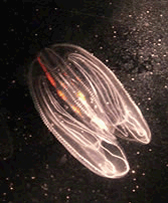
Ctenophores are now seen to be more important predators on larval hard clams than previously realized.eployed in central Great South Bay
One research project, conducted by graduate student Marianne McNamara, Professor Darcy Lonsdale, and Cerrato, focused on the impact of ctenophore predation on hard clam larvae and other plankton. It revealed that the populations of hard clam larvae were negatively affected by the earlier emergence of the ctenophores each year. Cerrato said the advanced appearance of the ctenophore during clam spawning season in July might be linked to climate change.
“The reason why we think this shift occurred is that the ctenophores are better able to survive winter,” said Cerrato. “The timing of the clam spawning season hasn’t shifted, but the time when ctenophores reach their peak abundance seems to be earlier now than a few decades ago. Now, ctenophores have become a very important predator of the clams.”
Another research project, led by Dr. Jackie Collier with graduate student Yuan Liu, focused on characterizing temporal and spatial changes in the microbial community. “So far, our results show that the plankton community in Great South Bay (both the eukaryotes and bacteria) generally changes on the scale of weeks… meaning one set of organisms will be dominant for a few weeks, then another set will take over for a few weeks… but is usually fairly similar in space at any given time,” commented Collier via email. “Although we still have a lot of work to do on the statistical analysis, so far our data suggest that the presence of Aureococcus anophagefferens blooms (brown tides) does impact the rest of the plankton community, including the bacteria, but that many other factors (temperature being a major one) also play a role. To our surprise, wind may be an important factor that nobody has really considered much before.”
Collier offered that the reason why brown tides occur as they do is unclear, which would make environmental management of systems, like that in the Great South Bay, difficult.
Another project aims to determine how highly-mobile species utilize the Bay and its many tributaries. Led by Dr. Frisk and graduate student Martha Divver, this research specifically focuses on the movements of white perch and blue crab. Animals are fitted with acoustic transmitters and their movements are tracked in the Carman’s River and other areas of the Bay.
“There’s a whole group of semi-anadromous fish in the creeks and the rivers in Great South Bay and we know almost nothing about them,” said Cerrato. Acoustic receivers have been emplaced in several tributary streams to detect the location and movement of tagged fish and crabs. “There has been a lot of field work, which is what I wanted,” said Divver. “I spent a lot of time on the water, but it’s been really good. We’re getting a lot of good feedback from the fish movement data.”
On the largest tributary to the Bay, the Carmans River, 15 receivers have been put in place and they have collected some of the most interesting and notable data of the tagging project. “Some of the data that we’ve been getting from the Carmans has been really interesting,” said Cerrato. “We’ve seen all kinds of different patterns in the behavior of fish. There are a few fish that don’t seem to move around very much. We have seen fish move up or down the whole length of the River in a single day. One white perch left the River entirely for two months and came back again. With the crabs, we also saw something interesting. They came out of the Carmans and, instead of moving towards Fire Island inlet and the ocean, they went into Moriches Bay, something we didn’t expect them to do.”
Monitoring Highlights
Closely related to the monitoring phase of the study are two projects, one focused on the temporal and spatial dynamics and distributions of phytoplankton and nutrients and another, led by Drs. Charles N. Flagg and Robert E. Wilson, that is monitoring the movement and circulation of the Bay’s water.
“To try to tie it all together, you really need to know where the water’s been and where it’s going,” said Flagg. “Initially, we were doing a numerical circulation model that was the big unifying thing. We have a version of that model that is sort of focused on the big volume of the Great South Bay, which is its eastern portion. The western portion of the Bay is vastly more complex.”
Work continues to incorporate the complicated topography of the western portion of the Bay, with a multitude of marsh islands and interconnecting channels, into the hydrodynamic model. The broad and open eastern portion of the Bay has been studied since 2004 using SeaCats, devices that autonomously collect salinity and temperature data. They were, and remain, installed at several points along the Bay shoreline: Smith Point; Bellport; Blue Point; Islip; Tanner Park and Barrett Beach on Fire Island.
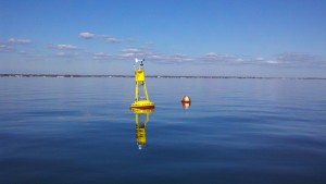
The centerpiece of the monitoring component of the study is an oceanographic/meteorological buoy, which is positioned in central Great South Bay. This semi-permanently installed device continuously measures wind speed and direction, air temperature, humidity, photosynthetically active radiation, water temperature, salinity, chlorophyll-a and turbidity. Flagg said observations from the buoy have revealed the system’s short-term variability. Buoy data feed into the coupled hydrodynamic and lower trophic model that is being used to examine the effect of wind and tide on the distribution of plankton and passive tracers.
Once completed, this multi-faceted study, when used in the context of ecosystem-based management, could provide a complex view of what might happen if aspects of the Bay’s environment are altered. “The concept with ecosystem based management is that someone’s got to be able to give you a thorough picture of all the implications of a current or projected human activity,” said Flagg. “The concept is that the thing works in a holistic way and everybody is connected to everybody else.”
As the Great South Bay Ecosystem Study winds down, SoMAS scientists will be increasingly working with local and state resource managers to explain and discuss the study’s findings and to demonstrate the capabilities of the linked simulation models as tools to predict the impacts of natural and human actions, including efforts to restore aspects of the Bay’s ecosystem. The goal is better informed and, ultimately, more effective management of this cherished and important environmental resource…Great South Bay.
More information on this project is available on its web page, http://www.somas.stonybrook.edu/research/gsb_ecosystem.


Recent Comments