Tides and Extreme Weather
Tides
Strong currents wash the West Meadow wetlands, both within West Meadow Creek and outside along the beachfront. Knowledge of the timing, direction, and strength of these currents is essential both for safety, fishing, and recreation. In addition, tides have important ecological effects on both mobile and bottom creatures.
The force of gravity acting between any two bodies is proportional to the product of the masses and inversely proportional to the square of the distance. In plain language that means that the force of attraction increases more quickly from increasing closeness of two bodies (such as the earth and the moon) than their relative masses. Both the moon and the sun exert significant effects on the earth, but the proximity of the moon makes it approximately six times more powerful than that of the larger but more distant sun. Tidal water motion can be measured anywhere in the ocean but it is especially noticeable near shore.
The extent of the tide is mostly determined by a difference in gravitational attraction on either side of the earth. Remember that the earth rotates about its axis once per solar day. At any time, the side of the earth closer to the moon has an excess of gravitational attraction and water is pulled toward the moon. On the opposite side of the earth from the moon, there is an excess of centrifugal force and water sort of spins away from the moon. So, the side of the earth facing the moon and the side opposite has times of high water, or high tide. At the same time depressions of water levels develop on the sides of the earth. Because the earth rotates once a solar day, you will have two times a day that a given location on the earth’s surface is either facing the sun or facing away. This results in two high tides, and two low tides, per day in any location. Keep in mind that the earth is rotating, so you stand still on a spot on the earth, which rotates to various positions that determine whether it is low, high or changing tide.
Things can get more complicated but in the New York area we have this very pattern of two highs and two lows in a day.
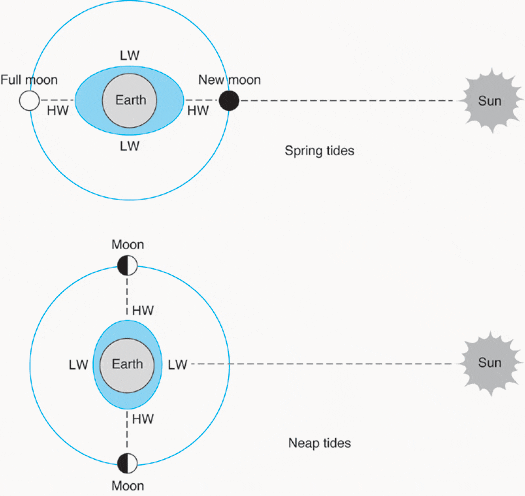
Not all tides are equal. Look at the figure below. You can see that at certain times the earth, moon and sun are approximately in line (full moon and new moon), which exagerates the gravitational pull on the water of the earth. At these times (every two weeks) we have a maximum of tidal range: the highest highs and the lowest lows. This time is known as spring tide, and tidal currents are also the strongest during this time. When the sun, moon, and earth form an approximate right angle (quarter moons) the effects of gravity partially cancel out and we have a small range of tide (relatively low high tides and relatively high low tides), known as neap tide. Two spring tides and two neap tides occur each lunar month, which is approximately 29.5 days long.


Left: Spring high tide at time of new moon at Hercules, Stony Brook village 12/10/04
Right: Low tide, 1/3/05

Looking across West Meadow to west. An extraordinary spring high tide 12-23-2022. 1000h. The West Meadow peninsula was flooded over.
Tide tables are available on the web. For complete tidal tables, you should consult NOAA tidal tables for the east coast of North America.
Tides are given for the open coast of Long Island Sound, but there is a significant delay within West Meadow Creek, where high tides and low tides are full 1 1/2 hours delayed after the corresponding tides on the outside at the beach. High tides are usually amplified by concurrent onshore winds.
Extreme Storms
Tides alone are capable of causing coastal flooding. But extreme weather, including hurricanes and strong storms, can cause unexpected damage to West Meadow and the larger area of Smithtown Bay and Stony Brook Harbor. Hurricane Sandy hit the New York City area on October 29, 2012 and caused major storm surge, wind and rain damage to the New York area and also to West Meadow. Storms are especially damaging when they arrive at the time of spring high tides. An unfortunate recent event occurred in 2024 in the night of August 18, and strong rains exceeded 10 inches in parts of Long Island, reaching a peak at spring high tide late at night. The tidal peak luckily only caused minor erosion around West Meadow, with strong erosion of pathways and sediment on some cliff areas. But the outcome was very different at the the Stony Brook Grist Mill, in Stony Brook Village, where a dam burst. The Grist Mill was installed in 1751, was used to mill flower and even to crush grapes for wine, and had been last used in the 1950s. The bursting of the dam, resulted in catastrophic emptying of the entire Stony Brook Pond, which resulted in collapse of a road, erosion, and pouring of water and thousands of freshwater fish, turtles, and other creatures into salty Stony Brook harbor, who died in the salt water. The catastrophe must have occurred in less than an hour or two, and at least one nearby house was severely damaged beyond repair. A dam was also breached in nearby Smithtown, which emptied Stump pond.
Should the dams be restored?
Stony Brook’s village pond is a consequence of the construction of a dam, whose water pressure ran a grist mill. Thousands of such dams were built over the past few hundred years and they provided useful power and flood control. But they also came with a price. Many species of valuable fish, including salmon, brook trout, eels and alewives used the rivers as vital connections in a life history that required migrations between the sea and upland river habitats for reproduction and juvenile survival. The brook trout no longer run from the sea in many of these impounded streams, like Stony Brook, the Connetquot River, and the Nissequogue River. As a few dams have been breached on Long Island, we have seen these sea-upriver connections restored with the re-establishment of riparian zones and natural vegetation. Maybe a new ecological and fish-saving view of these rivers will change our view of the dams. Already after a couple of weeks, you can see the natural “Stony Brook” being re-established. Maybe a conversation will commence about these dams and the artificial ponds they created in another time, with other needs that no longer exist.


Drone Shots of aftermath of collapse of dam at Stony Brook grist mill. Images taken by Nathan Levinton.

Damage to pond and road at the grist mill breakthrough. Photo by Jeff Levinton
Back to West Meadow Wonderland