

Radar Technology
Millimeter Radars
The choice of operating wavelength for a radar (from radio detection and ranging) is framed by two physical realities. For radars with the same resolution volume and transmitted power, as the operating wavelength gets shorter the radar is capable of detecting smaller particles (Lhermitte 1987); but, as the operating wavelength of a radar decreases the transmissivity of the atmosphere also decreases. For large, strongly reflecting features (e.g. aircraft, precipitating particles, birds) centimeter (1-10 cm) wavelengths are chosen to maximize radar signal transmission distances, because these targets scatter sufficient power back to the radar to be detected over hundreds of kilometers from the radar. Cloud particles with diameters in the range from 5 to 10 μm are most often too small to be detected by centimeter-wavelength radars. To detect cloud particles reliably, shorter millimeter-wavelength radars are necessary. However, the drop in atmospheric transmissivity from centimeter to millimeter wavelengths limits the range of millimeter-wavelength radars. In precipitation-free conditions a range of tens of kilometers is possible, but with the onset of precipitation the useful observation range decreases.
Millimeter-wavelength radars complement the popular and widely used centimeter-wavelength radars (e.g., National Weather Service radars and television station radars), of which the general public is most aware, in that in addition to precipitation storms, they are also capable of detecting nonprecipitating clouds. Clouds have a profound impact on the Earth’s climate. Their study has become a topic of great interest during the past 20–30 yr and millimeter-wavelength (cloud) radars have emerged as an important tool in characterizing their properties. Cloud radars are now being used in conjunction with lidar systems—one of the principal tools from the 1980s—in the study of clouds, including thin cirrus. Because of their short wavelengths, cloud radars have excellent sensitivity to small cloud droplets and ice crystals, can be configured to have high temporal and spatial resolutions, and can operate with antennas that have narrow beamwidths and limited sidelobes (Clothiaux et al. 1995; Kropfli and Kelly 1996; Lhermitte 1990). Their portability and compact size make them a powerful research tool that can be deployed on various platforms, including ships, aircraft, and satellites. ”

Scanning Cloud Radars
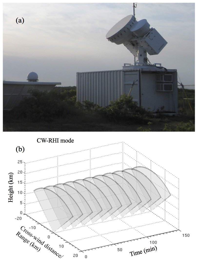
” […] The radar observations of clouds were obtained with vertically pointing Ka-band millimeter-wave cloud radar (MMCR; Moran et al. 1998) and W-band ARM cloud radar (WACR; Widener and Mead 2004). The long-term time–height profiles of clouds provided by MMCR and WACR have been instrumental in better understanding clouds (Remillard et al. 2012; Shupe et al. 2011; Kollias and Albrecht 2010; Protat et al. 2010; De Boer et al. 2009; Kollias et al. 2009; Mace and Benson 2008; Kollias et al. 2007b; Dong and Mace 2003). However, complete four-dimensional (space–time) characterization of the cloud formation process and cloud dynamics has never been achieved. Parameterizations of clouds form a significant part of uncertainty in global climate models. Although MMCR and WACR provide long-term high-resolution vertical structure of clouds, they are limited to making observations in the time–height domain and are not intended for three-dimensional mapping of clouds (Kollias et al. 2007a).
Currently, the ARM radar infrastructure includes dual-frequency scanning cloud radars operating at X band (9.4 GHz), Ka band (35 GHz), and W band (94 GHz). In addition to the scanning cloud radars, the ARM sites feature scanning precipitation radars operating at X band and C band (5.6 GHz). The augmented radar capability will enable researchers to better characterize cloud properties and study cloud–precipitation interaction. The observations from the scanning cloud radars will help in minimizing the uncertainty associated with cloud parameterizations used in global climate models. […] ”
Phased Array Radars
In the weather radar arena, there has been a lot of activity in the supplementation and replacement of present weather radar network of large radars with hundreds of smaller radars, which can be easily set up on existing sites, such as rooftops and cellular towers. An intelligent network will connect these small radars, which run on less power and for a lower cost than their larger counterparts, so that they can feedback data about atmospheric conditions near the Earth’s surface through collaborative and adaptive sensing (www.casa.umass.edu). One of the key elements of this network are the electronically-scanned phased array antennas, which are critical because they can be easily installed on existing infrastructure and lack moving parts that can be expensive to maintain. “The closer spacing of these radars will avoid the obstruction caused by the Earth’s curvature and allow forecasters to directly view the lower atmosphere with high-resolution observations,” observes Kollias. This adds a totally new dimension to existing weather observation by offering better forecasting of storms, resulting in improved warnings and faster response to weather-related hazards.
Our group conducts research on the marriage of weather and climate observing resources with a range of scientific goals. In particular, our group is involved in the first deployment of phased-array radars in Canada in collaboration with Environment Canada.

G-band Radars
“Our understanding of the physical processes governing cloud and precipitation is currently limited by gaps in our ability to remotely observe vertical profiles of the underlying microphysics. It is clear that a significant leap forward in this understanding can only come from observation systems which provide an increasing number of independent measurements. [….]
In this work we have proposed the use of multi-frequency Doppler techniques, combining 35GHz radars with radars operating in the G band, to significantly improve our profiling capabilities in three key areas: boundary layer, cirrus and mid-level ice, and snow-precipitating clouds. These cloud systems are characterized by particle hydrometeor sizes in the millimetre range. This implies that millimetre-radar backscattering signals are not simply proportional to the square of the mass of the scatterer like at centimetre (or longer) wavelengths, but present a weaker mass dependence. The reduction in reflectivities compared to the Rayleigh reference is related to particle size and habit, and carries critical information that can be injected into retrieval algorithms. […]
This work demonstrates that multi-frequency radar techniques, which would combine observations from G band Doppler radars with Ka or W band radar measurements, may significantly contribute to solving the microphysical deadlock in some key sectors of cloud physics. Given this premise, more than 30 years since the first measurements with such systems and after almost 25 years of inaction, we urge the entire remote sensing scientific community towards revitalizing the construction, deployment and exploitation of G band radars for cloud and precipitation studies. […] ”
EarthCARE Satellite
The EarthCARE satellite is a joint mission by the European and Japanese Space Agencies scheduled for launch in 2016. Data from its Cloud Profiling Radar with Doppler capability, High Spectral Resolution Lidar and Multi-Spectral Imager will be used to retrieve global profiles of cloud, aerosol, and precipitation properties and the predicted radiation compared with the observations made by its Broad-Band Radiometer. EarthCARE can be considered an evolution of the very successful CloudSat (Stephens et al, 2008) and CALIPSO (Cloud-Aerosol Lidar and Infrared Pathfinder Satellite Observations; Winker et al, 2010) satellites that were launched into the A-train constellation in 2006. In contrast to the A-Train satellites 700 km orbit, EarthCARE will carry four instruments on a single platform. The figure describes instrument sampling geometries.
EarthCARE’s 355-nm High Spectral Resolution Lidar (ATLID) will measure directly and accurately cloud and aerosol extinction, or optical depth, along with depolarization ratio, which when combined with backscatter will lead to much better identification of aerosol type. The EarthCARE Cloud Profiling Radar (CPR) will be Dopplerized, and so give additional information on convective motions as well as ice and rain fall speeds. The Multi-Spectral Imager (MSI) will provide contextual information and when used with ATLID and CPR data in an optimal estimation technique will yield profiles of aerosol, cloud, and precipitation properties and associated errors. MSI data will also be used to broaden the narrow curtain of retrieved cloud and aerosol properties. The resulting 3D domains will be used to initialize 1D and 3D broadband radiative transfer models. Estimated fluxes, heating rates, and radiances will then be computed and top-of-atmosphere (TOA) radiances and fluxes compared to those derived from data from EarthCARE’s Broad-Band Radiometer (BBR). In addition they will be used for assessing radiative transfer models with the goal of comparing observed and modeled TOA fluxes to within 10 W m-2 for domains of area about (10 km).
