


Shallow convection plays a critical role in the heat and moisture transfer between the boundary layer and free atmosphere above about 2 km. However, with an average spatial scale of 0.5–1.5 km, shallow cumuli are not resolved in weather forecast and climate models, and their broken cloud coverage results in uncertainties in estimations of domain-averaged cloud fraction profiles (CFP). Prof. Pavlos Kollias’s group (SoMAS), sponsored in part by the U.S. Department of Energy‘s (DOE) Atmospheric Radiation Measurement (ARM) Climate Research Facility and DOE’s Atmospheric System Research (ASR) Program, collaborated with Dr. Satoshi Endo and Dr. Andrew. M. Vogelmann, scientists of Brookhaven National Laboratory, Dr. William. I. Gustafson Jr. of Pacific Northwest National Laboratory, and Dr. Aleksandra Tatarevic and Mr. Kirk W. North, of McGill University, to understand the capability of radar observations for estimation of cloud properties (e.g CFP) and evaluation of the large eddy simulations (LES) for shallow convection over land.
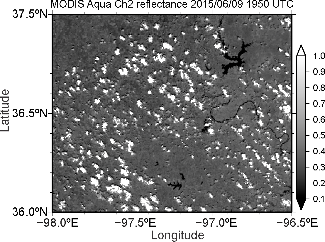
Figure 1: Shallow cumulus clouds (shown as bright regions) observed by satellite over the Southern Great Plains on 9 June 2015. The figure shows satellite-observed reflectance.
This study used LES output from the LES ARM Symbiotic Simulation and Observation (LASSO) capabilities currently under development and of the Routine ARM Aerial Facility Clouds with Low Optical Water Depths (CLOWD) Optical Radiative Observations (RACORO) field campaign. The LES outputs provided detailed shallow cumulus cloud fields that serve as proxies of true cloud fields in this study (Figure 2a). The LES combined with to the Cloud Resolving Model Radar SIMulator (CR-SIM), which is a scanning and profiling multi-parametric radar simulator capable of emulating the interaction between transmitted polarized radar waves and rotationally symmetric hydrometeors, provide an estimate of what can be observed in the atmosphere.
Uncertainties in domain-averaged CFP estimates were addressed using LES of shallow convection over the Southern Great Plains coupled with the CR-SIM. Analysis of the radar simulation indicated that observation from a single vertically-pointing Ka-band radar (KAZR) is inadequate to provide reliable CFPs (Figure 2b). Use of Ka-band scanning cloud radar (Ka-SACR), performing a sequence of cross-wind horizon-to-horizon scans, is not straightforward because radar sensitivity decreases with distance as shown in Figure 2a. Sampling a small region in the vicinity of Ka-SACR ensures higher sensitivity, but this results in undersampling the overall cloud field. Alternatively, a larger sampling region ensures sampling more clouds, but the lower sensitivity farther from the radar underestimates the CFP.

Figure 2: (a) Horizontal cross sections of hydrometeor mixing ratio from the LES (left column) and Ka-band reflectivity (right column) at 4.19 km (top) and 2.42 km (bottom) above ground level. Xs in represent the center of LES domain and the location of the Ka-band scanning cloud radar. Radar sensitivity was applied to the reflectivity plots assuming cross-wind horizon-to-horizon scans (CWRHI). Radar sensitivity decreases with distance as shown in Figure 2a, causing uncertainty of CFP estimates. (b) The CFP from hydrometeor mixing ratio over the LES domain, and CFPs from 10 KAZR dwells with their mean CFP and standard deviation. Even 10 Ka-band zenith-pointing radar dwells (thin colored lines) cannot capture the domain-averaged CFP (black dashed line).
Using the cumulative distribution function (CDF) of reflectivity as a function of altitude, as depicted in Figure 3a, an optimal minimum detectable reflectivity at each height is determined from the CDF isoline that provides an optimum selection of region size and radar sensitivity. CFP from the optimum regions using this new method shows good agreement with the model CFP. The Ka-SACR observations need to be conducted for 35 min or more for CFP estimates to converge with the LES-simulated CFP (Figure 3b) with an RMSE less than 1% on the order of 5% CFPs.
The new techniques developed in the study increase confidence in the retrieved CFP when looking at the true atmosphere and improve our ability to compare model output with cloud radar observations for shallow cumulus cloud conditions.
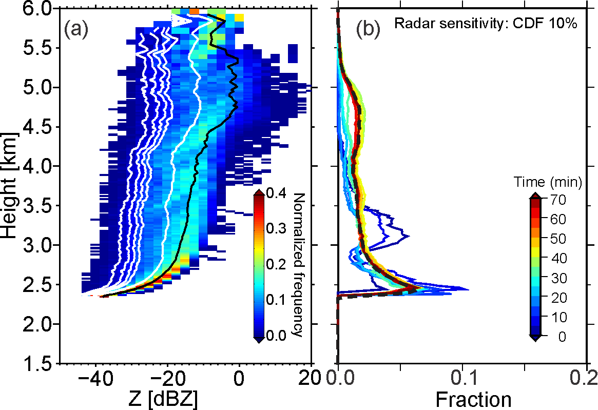
Figure 3: (a) Contoured frequency altitude diagram (CFAD) of simulated Ka-band reflectivity for 9 June 2015 at 2100 UTC. Black line represents the mean profile and white lines represent CDF isolines of 5, 10, 15, 20, and 50% going from left to right. (b) Cloud fraction profiles corresponding to the 10% CDF isoline with changing scan duration time (colored lines). Black dashed line in (b) represents the LES domain-averaged CFP for hydrometeor mixing ratio ≥ 0.01 g kg-1.
Using the cumulative distribution function (CDF) of reflectivity as a function of altitude, as depicted in Figure 3a, an optimal minimum detectable reflectivity at each height is determined from the CDF isoline that provides an optimum selection of region size and radar sensitivity. CFP from the optimum regions using this new method shows good agreement with the model CFP. The Ka-SACR observations need to be conducted for 35 min or more for CFP estimates to converge with the LES-simulated CFP (Figure 3b) with an RMSE less than 1% on the order of 5% CFPs.
The new techniques developed in the study increase confidence in the retrieved CFP when looking at the true atmosphere and improve our ability to compare model output with cloud radar observations for shallow cumulus cloud conditions.
Publication:
About the Author
Mariko Oue received a degree of Ph.D in environmental science in 2010 at Nagoya University, Japan, followed by postdoctoral research at Nagoya University and the Pennsylvania State University. I am currently a postdoctoral researcher at SoMAS since 2016, studying on cloud dynamics/microphysics using polarimetric Doppler radars. Clouds are composed of many tiny particles such as cloud droplets, raindrops, and snowflakes and play a key role in climate. My interest is formation pricess of cloud and distributions and growth processes of the cloud/precipitation particles observed by radars.
