


Motivation
Deficiencies exist in our understanding of fundamental processes impacting summertime density stratification and its influence on hypoxia in the Long Island Sound (LIS). These include poor knowledge of: 1) subtidal circulation and its influence on water property residence times, 2) over-water air-sea fluxes, 3) contributions from both the above to LIS heat and mass budgets, 4) contributions from 1-D vertical processes versus 3-D advective processes, 5) the significance of atmospheric synoptic variability, and 6) the extent that interannual variability modulates these processes. Hypotheses associated with each of these scientific issues remain untested because of crucial shortcomings in our observational base. The ramifications of this lack of data are significant because coupled hydrodynamic/water quality models must necessarily be supplied or constrained by measured fields. Thus, shortcomings in the observational record contribute directly to uncertainty in LIS modeling efforts and in turn to LIS management plans. The above considerations motivate the following scientific objectives that are associated with this project:

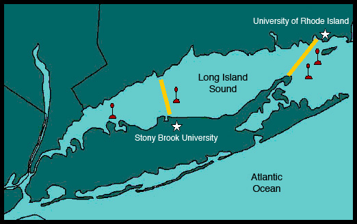
To develop a ferry-based observing system for Long Island Sound environmental studies based on one transect in the central Sound and one in the vicinity of the Race.
Obtaining marine and over-water atmospheric measurments is extremely, and often prohibitively, expensive. However, having such data is crucial in order to address many scientific questions associated with the physics, chemistry and biology of the Long Island Sound and its interaction with the atmosphere. The potential for using Long Island Sound ferries as observing platforms represents a tremendous opportunity for obtaining routine, long-period records of a number of important environmental variables. As proposed and outlined by the Joint Research Project, the specific plan for developing the Long Island Sound ferry-based observing system involves equiping ferries along the Bridgeport – Port Jefferson (BPJ) and New London – Orient Point (NLOP) transects with marine sampling instruments and in addition equiping the BPJ ferry with meteorological instruments. The marine instrument packages include Acoustic Doppler Current Profilers (ADCPs) to measure the vertical profile of the current along the ferry transects and sensors to measure the temperature, salinity, dissolved oxygen and Chlorophyll of the near-surface waters. The meteorological package includes sensors to measure near-surface atmospheric temperature, humidity, pressure, wind, rainfall as well as incoming solar and infrared radiation. This suite of meteorological instruments, along with the sea surface temperature measurements, provides the means to estimate the exchange of heat, momentum and freshwater between the atmosphere and the Long Island Sound.
Both systems are to be monitored in real-time using cellular modem connections that will allow the data to be transferred in real-time (e.g., within 10-15 minutes) and provide the means to respond more rapidly if components of the system become inoperable. Each system will also include a Global Positioning System (GPS) to provide the latitude and longitude for each data sample as well as a compass to provide vessel orientation. In addition, data will be displayed on board the ferries as well in real-time to provide the observed information to the passengers and crew. Details regarding the technical framework and instruments for the BPJ ferry are given under System Description.
It is important to note that use of the ferries represents substantial in-kind contributions, without which would entirely prohibit the above sort of sampling scheme and thus the ability to address many of the project’s Scientific Objectives.

To determine the relative contributions of local atmospheric forcing and advective transport to the evolution of Long Island Sound density stratification and thus to the evolution of Long Island Sound hypoxia events.
The schematic above illustrates the processes involved in determining the temperature of the ocean surface. At the air-sea interface, these mainly include heat transfer due to solar radiation, infrared radiation, evaporation and conduction. Contributing processes in the ocean include advection of warm/cool water due to currents and vertcal mixing between warmer (i.e. lighter) water in the upper portion of the water column and cooler (i.e. heavy) water in the lower portion of the water column. The numbers for the atmospheric processes above are in Watts per meter squared and are based on globally averaged values. For any given region (such as the Long Island Sound), time of day, season, and current weather condition, the contribution from each of the above processes will vary. During the summer months, surface heating processes in the Long Island Sound generally outweigh the cooling processes. This results in the development of vertical stratification, whereby warm (light) water develops and rests over cooler (heavy) water. Since strong wind events, which typically drive vertical mixing in the ocean and thus surface cooling, are rare in the summer, oxygen in the surface layers of the ocean is unable to mix downward and reach the bottom layers of the water column. This condition can result in the development of hypoxia (i.e. low oxygen). At present there is still significant uncertainty regarding the relative roles that the above atmospheric and ocean processes play in determining the development, evolution and breakdown of stratification in the Long Island Sound. Measurements obtained by this project will enable a more comprehensive examination of this question.

To determine the role of synoptic forcing on the development and breakdown of stratification and dissolved oxygen (DO) variability via its influence on vertical versus advective processes.
The strength of the vertical stratification (e.g., pycnocline) in the Long Island Sound is an important factor determining the evolution of the amount of dissovled oxygen (DO) in the bottom waters of the Sound, and in turn on the development of hypoxia. Over the course of the winter, the surface waters of the Sound cool considerably due to air-sea exchange processes (see Objective 2) and due to the greater frequency of strong wind events (i.e. storms) that keep the water colum vertically well mixed. Beginning in late spring, with the seasonal increase in solar radiation and the less frequent and weaker storm activity (e.g., left photo above) the surface waters begin to heat up and the column begins to stratify. This stratiifcation continues to strengthen over the course of the summer, leaving the bottom waters isolated from their primary source of oxygen Beginning in the fall, surface wind and cooling from clouds associated with stronger and more frequent weather disturbances begin to erode the stratification away until the column again becomes well mixed in the vertical (see Objective 5) and the bottom water DO becomes replenished. At present, there are still uncertainties regarding the manner that weather events (i.e. synoptic forcing), such as those depicted above, contirbute to both the development and breakdown of vertical stratification. This includes the weather’s effects on local air-sea exchange processes as well as on the variations in circulation in the Sound and its horizontal exchange with the Ocean via the Race. The ferry-based marine and atmospheric observations as well as the observations from the Joint Project’s profiling instruments will provide valuable information to help the address and reduce the above uncertainties.

To determine the properties of the Long Island Sound residual exchange flow at the two ferry transects.
Determining the characteristics of the mean water circulation of the Long Island Sound is important as it provides information on the time a given water parcel, or the chemical and hydrographic properties it may possess, may reside in the Sound before being exchanged with the surrounding ocean. However, determining this mean water circulation for the Long Island Sound is a significant challenge due to the lack of observations of ocean currents in the sound and due to the large “signal to noise” ratio associated with these measurements. In regards to the latter, it is important to note the mean circulation values are typically on the order of a few centimeters per second. However, the Sound experiences large tidal fluctuations which make this smaller value hard to detect. For example, the figure above shows the current profile over the course of three days in 1990 from an Acoustic Doppler Current Profiler (ADCP) that was mounted on the bottom of the Sound in a region close to the Bridgeport – Port Jefferson ferry track. Evident are the very strong east-west current fluctuations which given their (near) twice-a-day period are known to be associated with tides. From this figure it is difficult to determine if the current in this region has a mean, non-zero residual value. In order to determine the mean value of the current from this sort of data, it is necessary to have quite long records (~weeks to months) in order that the tidal fluctuations can be averaged out of the record, leaving only the mean “residual” circulation. For this project, ADCPs are mounted on each particpating ferry. Data from these instruments/ferries will thus provide valuable information on the current structure across the the central and eastern end Sound. Having relatively long records of current variability at these two ferry transects will allow a greatly improved estimate of the residual circulation of the Sound and the associated flushing/exchange times with the surrounding ocean.

To refine estimates of Long Island Sound basin-wide annual cycle budgets of heat, mass and salt.
At present, there are still uncertainties associated with determining the exchanges of heat, water mass, and salt between the Long Island Sound (LIS) and its surrounding environment over the course of a typical year (i.e. climatological variations). In the case of water mass or salt, the question involves considering the water exchanges at both the east (via the Race) and west (via the East River) ends of the LIS, as well as the freshwater inputs from the surrounding rivers, groundwater runoff and local rainfall. In the case of heat, the question involves determining the heating/cooling contributions that occur between the atmosphere and the ocean (i.e. air-sea exchange; see Objective 2) as well as the heat exchange that occurs via ocean currents at either end of the Lis (mainly via the Race). The diagram above illustrates the present uncertainty associated with our knowledge of the air-sea exchange over the Long Island Sound. Each panel shows an idealized model depiction of the vertical temperature structure of the LIS and its changes over the course of one calendar year. The difference in each panel is that each model simulation used a different, yet reasonably posed, estimate of the air-sea heat exchange over/near LIS. However, because of the lack of observed values of air-sea heat exchange directly over LIS, each of these estimates are based on data mainly south of Long Island, and none of the estimates involve direct measurements of the solar and infrared radiation processes but rather use approximations based on subjective cloud reports. Evident from the diagrams above is the significant uncertainty in these heat exchange estimates and the impact this uncertainty has on our understanding of the evolution of temperature (i.e. heat content) of the LIS. Measurements obtained by this project will provide the means for constructing more accurate estimates of the exchanges of heat, water mass and salt for the LIS.

To develop multi-decade retrospective time series of over-water Long Island Sound surface fluxes and relate their low-frequency variations to variability in Long Island Sound stratification and bottom dissolved oxygen (DO).
The development of hypoxia in the Long Island Sound (LIS; see Background) can arise from anthropogenic (i.e. man-made) and/or natural processes. Determining the contribution from each is important when it comes to water quality management. For example, when severe hypoxia occurs in a given summer, water management authorities seek to understand the causes. If it is determined that the causes were mainly anthropogenic in nature (e.g., increased affluent discharge), it might be necessary to put forth significant effort and financial/community resources to try and limit the occurrence in future years. On the other hand, if there appeared to be no change in the anthropogenic interactions with the LIS but rather if it could be determined that the weather/climate was particularly conducive to the development of hypoxia, there would be less or no reason to make any changes in water management practices.
At present, there is still a great deal of uncertainty associated with our knowledge of the manner that climate and weather variations affect the LIS and its water quality, and in particular the development of hypoxia. Knowing the variations in the exchanges of heat, momentum and salt/freshwater between both the LIS and the atmosphere via air-sea exchange and the LIS and the ocean via horizontal currents (see Objective 2) is important since both of these play a significant role in establishing the summertime pycnocline. There is strong evidence that natural variations in these physical processes play a role in the development of hypoxia. For example, the uppermost time series plot in the figure above shows dissolved oxygen (DO) in the bottom waters of the LIS (near Hart Island) for the period 1946-98. Evident are the year-to-year variations in bottom DO. The middle time series plot shows the associated year-to-year variations in the temperature difference between surface and bottom water. This quantity represents a measure of vertical stratification (i.e. strength of pycnocline), with greater stratification facilitating favorable conditions for hypoxia to develop. Two things are worth noting in regards to these time series and their correlation (shown in the lowest panel). First, variations in stratification are known to be associated with variations in heat, momentum and salt/freshwater exchange – and thus are considered to be driven by natural processes. Second, there appears to be a relatively strong relationship between bottom DO and vertical stratification indicating that natural processes do in fact play a significant role in year-to-year variations in bottom DO and thus the development of hypoxia.
To facilitate the interpretation of the historical record of hypoxia events and their underlying causes, one aim of this study is to develop a multi-decadal estimate of the exchange of heat, momentum and rainfall between the atmosphere and the LIS. This estimate will necessarily be developed from surrounding land-based observation sites where long records of observations are available (e.g., La Guardia Airport). However, these longer, land-based records can only depict the exchanges occurring over the LIS so accurately. The ferry-based observations provide actual over-water values of the above quantities so that the long-record estimate can be better constrained. Having such long-period records of air-sea exchange properties will help to determine the extent that natural variations played a role in past variations of LIS bottom DO and in turn help to guide future water quality management decisions.