


John Gondek, Bingqi Cheng and Anne McElroy, Aquatic Toxicology Lab, School of Marine & Atmospheric Sciences — Using in-ovo EROD Activity in the Embryos of Japanese Medaka (Oryzias latipes) as a Sensitive Measure of Organic Contaminants in Sediment

John Gondek and Anne McElroy
The study of contamination in marine ecosystems is important in understanding anthropogenic effects on the environment. Many contaminated soils contain agonists such as PCB’s and PAH’s. These toxicants are metabolized by the induction of CYP450 via the aryl hydrocarbon (Ah) receptor. Activity of this metabolic pathway can be measured through the fluorescent product, resorufin. This is produced by the enzyme ethoxyresorufin-O-deethylase (EROD) when combined with an Ah agonist and the substrate ethoxyresorufin (ER). Nacci et al. utilized the in-ovo EROD method to measure contamination of water using killifish (Fundulus heteroclitus). Our lab has been adapting this method using other fish species and by testing the exposure effects of contaminated sediment. In the embryonic fish used, the contamination levels were measured by the accumulation of the florescent byproduct in the gallbladder. The brighter the fluorescence, the more the metabolic pathway had been activated, indicating higher amount of toxicants.
Japanese Medaka were used since they are easily reared and produce eggs daily. For the first trial, fresh eggs were collected and exposed to sediment from Riker’s Island (known high contamination level) and sediment from a reference site, Flax Pond (control). These were then left on screens on the sediments for 4 days, rotating the screens daily. After the 4 days, the eggs were placed in individual vials with a set concentration of 7ER. Embryos were incubated for 24hrs in the dark. After incubation, the eggs were rinsed in ERM then imaged using a fluorescent microscope. The embryos were then allowed to incubate and imaged for 48hrs and 72hrs. This first trial compared the signal response measured and the time the eggs were incubated.
The second trial repeated the above steps but using sediments from 7 different sites (Port Jefferson, Jamaica Bay, Oyster Bay, Raritan Bay, Hudson River, Little Neck and Flax Pond). The first trial indicated 48hrs incubation and imaging provided the best fluorescence without much background response. The eggs from the above sites were then imaged using the technique above. The images were then semi-quantitatively measured by using computer software to measure pixel density of the fluorescent gall bladders in the image.
The results show that compared to the control, all other sediment collection sites showed a higher level of CYP450 induction. This indicates a higher level of contamination in the soils at these sites. The results from these tests indicate that animals living in polluted habitats show metabolic reactions to their environment and these responses can be used to measure the contamination levels of these sites.
Robert Hunter and Malcolm J. Bowman, Stony Brook Storm Surge Research Group, School of Marine & Atmospheric Sciences — Towards an Operational Storm Surge Prediction Model for the Northeastern Seaboard
 The Stony Brook Storm Surge Project is investigating threats to the Metropolitan New York and Long Island areas from storm surges in an era of global climate change. We are developing an integrated meteorological-oceanographic-wave numerical model for real-time 60-hour forecasts of water level and coastal flooding using constantly-updated weather forecasts. Software is being developed to run daily a 9-member ensemble, using eight different meteorological forecasts and two ocean grids with different resolutions and domains. Throughout the past year, the model has been further refined by improving oceanographic model parameters and meteorological-oceanographic model integration. A new grid, with an increased domain and resolution, has been developed for the operational forecast model. A wave model is being run daily for the New York area, for future integration into the storm surge model. This winter, we are collecting data from significant storm events for long-term analysis of the model accuracy. Various data products for displaying and analyzing the predictions are being used for verification and improvement of the model. Our eventual goal is to provide a real-time warning system for conveying flooding threats to the public. Funded by New York Sea Grant; and by Undergraduate Research & Creative Activities (URECA).
Yang Li, Ward Melville High School and Edmund Chang, School of Marine & Atmospheric Sciences — Enhancement of Winter Mid-latitude Precipitation over North America by Upper Level Waves Propagating from the Pacific Ocean
 Numerous studies have analyzed the induction of mid-latitude cyclogenesis by preceding upper-level wave packets (Rossby waves). This project is the first to take a systematic look at the enhancement of the associated precipitation over North America by waves propagating from the West Pacific. Data collection began with a survey of upper level wave data from the meteorological winter months over eleven consecutive seasons (1996-2007). A classification system was created to select waves as 11-day cases. 172 wave (V) cases and 172 parallel precipitation cases (PCP) were compiled, and three statistical composites of these cases—a simple PCP mean composite, the total V composite, and the propagating V composite—were created. Another variable, PCP prime, was used to isolate the propagating (enhanced) PCP. Generally, across most relevant geographic areas, the composite wave centers were precursors to above average precipitation (PCP prime). The primary composite wave formed off the East Asian coast 6-7 days ahead of precipitation near the North American East Coast. The enhanced PCP on days +1 and +3 was particularly heavy. Overall, the wave-precipitation correlation was qualitatively strong, significant for most but not all locations. During the project, geographical areas of undefined data were resolved by removing associated cases from the composites.
Miguel D. Lopez, Bing Bing Wang, Paul L. Siegel and Daniel A. Knopf, School of Marine & Atmospheric Sciences — Homogeneous Ice Nucleation from Aqueous Particles Containing Surrogates of Biomass Burning Aerosols

Miguel D. Lopez
Ice particles in the atmosphere affect the global radiation budget by scattering and absorbing radiation, the water budget in the upper troposphere/lower stratosphere, and precipitation processes. Ice particles form from pre-existing aerosol particles at temperatures below the freezing point. Although its importance is highly recognized, aerosol-ice cloud interactions remain one of the largest unknowns to predict future changes in the global radioactive budget and thus in climate. Aerosol particles from biomass burning plumes originating e.g. from forest fires, can reach altitudes at which temperatures are low enough to promote the freezing of ice. It is expected that the wildfire frequency is increasing due to an increase in global temperature and consequently generating more biomass burning particles. Here, we study the effect of typical biomass burning compounds, such as levoglucosan, on ice nucleation. The formation of ice is observed using optical microscopy and is digitally recorded for subsequent analysis. First, we measure homogeneous ice nucleation from aqueous (NH4)2SO4 droplets which also serves experimental validation purposes. Then, we measure the freezing of ice from aqueous levoglucosan-(NH4)2SO4 particles and pure levoglucosan-H2O particles. About 50 droplets are deposited on a hydrophobically coated glass plate using a piezo-electric driven droplet dispenser or nebulizer. During sample preparation the droplets are exposed to a controlled humidified flow of helium that, in equilibrium, controls the composition of the particles. In this experiment, the droplets were exposed to relative humidities of 99%, 95%, 90%, 85% and 81%. Then the particles are sealed against ambient air and are exposed to temperatures as low as 190 K using a cryo cooling stage. Previous to the experiments the cryo cooling stage was calibrated measuring the melting points of water, octane, pentane and dodecane. From the digitally recorded ice nucleation experiments the freezing temperature, droplet diameter, and the time the droplets remained liquid are obtained to derive homogeneous ice nucleation rates. The ice nucleation rate is then applied to estimate if biomass burning plumes can be a significant source of ice particles in the atmosphere.
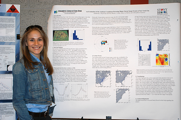
Katherine Rojowsky and Brian A. Colle, School of Marine & Atmospheric Sciences — An Evaluation of the Ambient Conditions Favoring Major Storm Surge
Katherine Rojowsky
A large fraction of the New York/ New Jersey metropolitan region is less than 5 m above sea level; therefore, much of the area is vulnerable to coastal flooding during major storm events. This was evident during the Nor’easter of 1992, in which a 1.7 m storm surge resulted in significant flooding in the New York City (NYC) area. In order to improve forecasting of these events, more understanding of the atmospheric conditions that favor storm surges around NYC is needed. We hypothesized that many storm surge events for NYC have similar storm (cyclone) tracks and evolution of the winds before and during the event. In particular, we are interested in the relationship between wind direction, strength, and duration during the more significant surge events.
In order to understand how the winds evolve at New York City during the more significant storm surge events, hourly surface observations at John F. Kennedy Airport were obtained for the 50 largest storm surge events since 1979 at The Battery, NYC. The surface wind speed and direction were analyzed 48 hours leading up to the time of maximum surge and 24 hours after the maximum surge. In addition, the tracks of the surface cyclones were obtained by identifying the minimum in central pressure at the surface every 3-h using the North American Regional Reanalysis (NARR) dataset.
The months of December and January have the largest frequency of maximum surge events at the Battery (21 out of the top 50 cases). At the time of maximum surge, there is a well-developed cyclone situated around the New Jersey coast. However, the track of the cyclones vary substantially, with some storms tracking northeastward offshore along the coast as a classical nor-easter, while others originate over the southeast U.S.. Most of the tropical cyclones track northward and parallel to the coast towards Long Island. The wind speeds increase from approximately 10 m s-1 24-h prior to the surge to 15-20 m s-1 at the height of maximum surge. The average wind direction steadily turns from the southeast (120o) to more northeasterly (75o) at John F. Kennedy airport during the 24 h period leading up to maximum surge at the Battery. There is a sudden shift to the southwest within 10 h after the surge maximum. The northeasterly wind direction prior to the maximum surge favors a storm surge in NYC because surface wind stress pulls water towards the concave coastline of the New York and New Jersey, while Ekman transport acting to the right of the wind helps pull water towards New York Harbor and the Long Island coast.
Michael Taddeo, Mark Sokolowksi, and Mark D. Fast, Marine Animal Disease Laboratory, School of Marine & Atmospheric Sciences — Prevalence of Mycobacteriosis in Striped Bass and Bluefish populations: A New York Perspective

Michael Taddeo
Several members of the bacterial genus Mycobacterium are piscine pathogens. Infection generally results in chronic disease, which may or may not manifest itself externally. Attention was called to the Chesapeake Bay system in the mid 1990’s after high levels of overt infection were reported in striped bass (Morone saxatilis). Extensive and continuing investigation into the epizootic has resulted in a greater understanding of the disease, improved diagnostics, and an estimation of prevalence within the population. Although the Chesapeake Bay and Hudson River stocks intermingle, little to nothing is known about the prevalence of mycobacteriosis in the Hudson River or New York State’s marine district as a whole. Additionally, we have only anecdotal evidence of the occurrence and prevalence of mycobacterial infection in bluefish (Pomatomus saltatrix), another important game fish species. Our study aims to estimate the prevalence of mycobacteriosis in striped bass and bluefish in the Long Island Sound and New York Bight using physical examination, nested PCR, nucleotide sequencing, and histology.
Striped bass and bluefish were collected from several Bays (Jamaica Bay, Little Neck and Manhasset Bays, Cold Spring Harbor, Oyster Bay, and the Lower Hudson River) using shore seining gear, as well as from trawls through the New York Bight. Tissue samples (spleen, anterior kidney, liver, and heart) were then taken from the individuals for use in direct PCR and histological preparation. PCR was performed on tissue homogenates with primers targeting the 16S rRNA gene; nested PCR was then performed with primers specific to the 16S gene of Mycobacterium genus members. Analysis of the PCR results is ongoing, and prevalence data will soon be compiled. PCR products are currently being sequencing to confirm the diagnosis. Additionally, histological examination is being performed on the excised tissues; mycobacteriosis often results in the formation of granulomatous lesions, which are indicative of the disease.
Characterization of piscine mycobacteriosis is important not only because of its effect on finfish populations, but because of its zoonotic potential. Contact with infected fish can result in fish handler’s disease, causing ulcerative dermatitis in humans. In addition, some piscine mycobacteria have been shown to harbor toxic mycolactone-encoding plasmids, which can then be acquired and expressed by other mycobacteria. Consequently, the zoonotic significance of piscine mycobacteria may be augmented by their potential to act as reservoirs of virulence-increasing factors.
This work has been funded by an MOU from the New York State Department of Environmental Conservation and the Marine Animal Disease Lab at SoMAS, Stony Brook.
Alexander Titus and Brian A. Colle, School of Marine & Atmospheric Sciences — Atmospheric Conditions Associated with Tornadoes on Long Island

Brian Colle and Alexander Titus
The goal of this research project paper is determine the atmospheric conditions that favor tornadoes on Long Island. Both the Atlantic Ocean and the Long Island Sound play an important role in modifying severe weather on Long Island. Typically, the relatively cool water stabilizes the low-level atmosphere, thus severe storms often weaken over the island. However, there have been 27 tornado reports on Long Island from 1958 to 2007. One objective was to determine the time of year and day that favors tornado events on Long Island as well as the large-scale atmospheric flow patterns around the Northeast U.S. associated with these events.
First, a database of tornadoes on Long Island was compiled using a program called SVR Plot2, which is a national database for severe storm reports across the U.S. The Long Island tornado events were separated into tornado location, the times in which the storms occurred, and the month. The dates of the tornado occurrences were composited on a 2 x 2 deg grid using the National Center for Atmospheric Research composite website (http://www.cdc.noaa.gov/Composites/Hour/), in which horizontal plots of the average weather conditions at each grid point was obtained by summing a particular meteorological variable (surface temperature, pressure, wind, etc…) from all tornadic storms at a grid point and then dividing by the total number of storms in the composite. Plots were compiled of the different layers of the atmosphere, as well as certain thermodynamic properties.
Overall, tornadoes on Long Island occur just as frequently in the morning as the evening, with an equal chance between 8 AM and 8 PM. This is in contrast to other locations in the Northeast U.S., which have a significant peak in tornado activity in the late afternoon. The most active month for tornadoes on Long Island is August as compared to June and July in other parts of the U.S. This may be attributed to surface temperatures reaching their peak on Long Island by August, since the surrounding waters also reach their maximum temperature around this time. The composite surface pressure pattern across the Northeast U.S. suggests that many tornado events have a trough approaching Long Island from the west, which results in large-scale ascent during these events. The low-level thermodynamic composites suggest a wedge of warm, moist, and unstable air extending northward along the mid-Atlantic coast to Long Island. The approaching cyclone advects this moist and unstable air northward into the region, which is likely the reason why there is little diurnal preference to tornado events on Long Island.
