Brad Peterson, Brad Furman
Great South Bay (GSB) is the largest of the South Shore Estuaries (SSE) and has historically been one of New York State’s most productive water bodies. It once played host to a number of economically important commercial and recreational fisheries including the eastern oyster (Crassostrea virginica), hard clam (Mercenaria mercenaria), winter (Pleuronectes americanus) and summer (Paralichthys dentatus) flounder, bluefish (Pomatomus saltatrix), tautog (Tautoga onitis) and striped bass (Morone saxatilis). However, decades of overfishing, increasingly degraded water-quality, the urbanization of the surrounding watersheds, the onset of eelgrass (Zostera marina) wasting disease, and the continued recurrence of Brown Tides have all but decimated the commercial shellfisheries and severely limited recreational prospects within the Bay. Understanding how these factors have driven losses of productivity and finding ways to predict future changes is critically important to the protection and management of GSB.
Central to that goal is understanding how changes in water quality affect the distribution of seagrasses within the estuary. By providing vital nursery and forage habitat, as well as stabilizing sediments and buffering the shorelines from storm erosion, seagrasses form the structural basis for the Bay’s foodweb and support much of its remaining productivity. As flowering plants, seagrasses require adequate sunlight to grow and reproduce. This requirement is unusually high for marine plants and typically limits seagrasses to the shallowest portions of the Bay, where the percent of surface light (irradiance) reaching the bottom exceeds an average of 22%. The depth at which this occurs depends not only on the angle and intensity of incoming sunlight (i.e., time of year and degree of cloud cover), but also on the clarity of the water (turbidity). The latter is influenced by the concentrations of particles, such as plankton and suspended solids, as well as the concentration of dissolved organics – often supplying a tea-stained appearance to the water. Over time, as water quality in the Bay has been impaired, the depth at which seagrasses can grow has been successively reduced, limiting not only the amount of seagrasses in the Bay, but also the productivity of the organisms that depend on them for reproduction and nutrition (Figure 1).
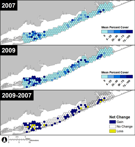
In our first steps toward a Bio-Optical model aimed at using easily measured water quality parameters to predict seagrass density and distribution, we have generated estimates of where that 22% cutoff occurred over a number of years, and compared that to seagrass surveys conducted over the same time-period (Figure 2). To test our preliminary findings in the field, we have begun locating seagrass beds that exist along depth gradients (slopes), where the deepest edge of the bed reaches depths at or beyond the predictions of our model. Studies into the growth characteristics of these grasses, living at the very limits of their light requirement, will provide the field data needed to validate future versions of the model. Also planned are the incorporation of more sophisticated methods of calculating light attenuation and scattering within the water column and integrating that into a predictive model of seagrass growth and productivity. These data can then be incorporated into a GIS to develop a spatially explicit model predicting seagrass distribution based on the ambient light environment as measured by a few, easily recorded parameters. Data provided by these efforts will allow governmental agencies and conservation groups to better understand precisely how impacts to the water quality of GSB connect to the many fisheries that they are tasked to manage and protect.


