


Vertical Velocity
Retrievals in Convective Storms
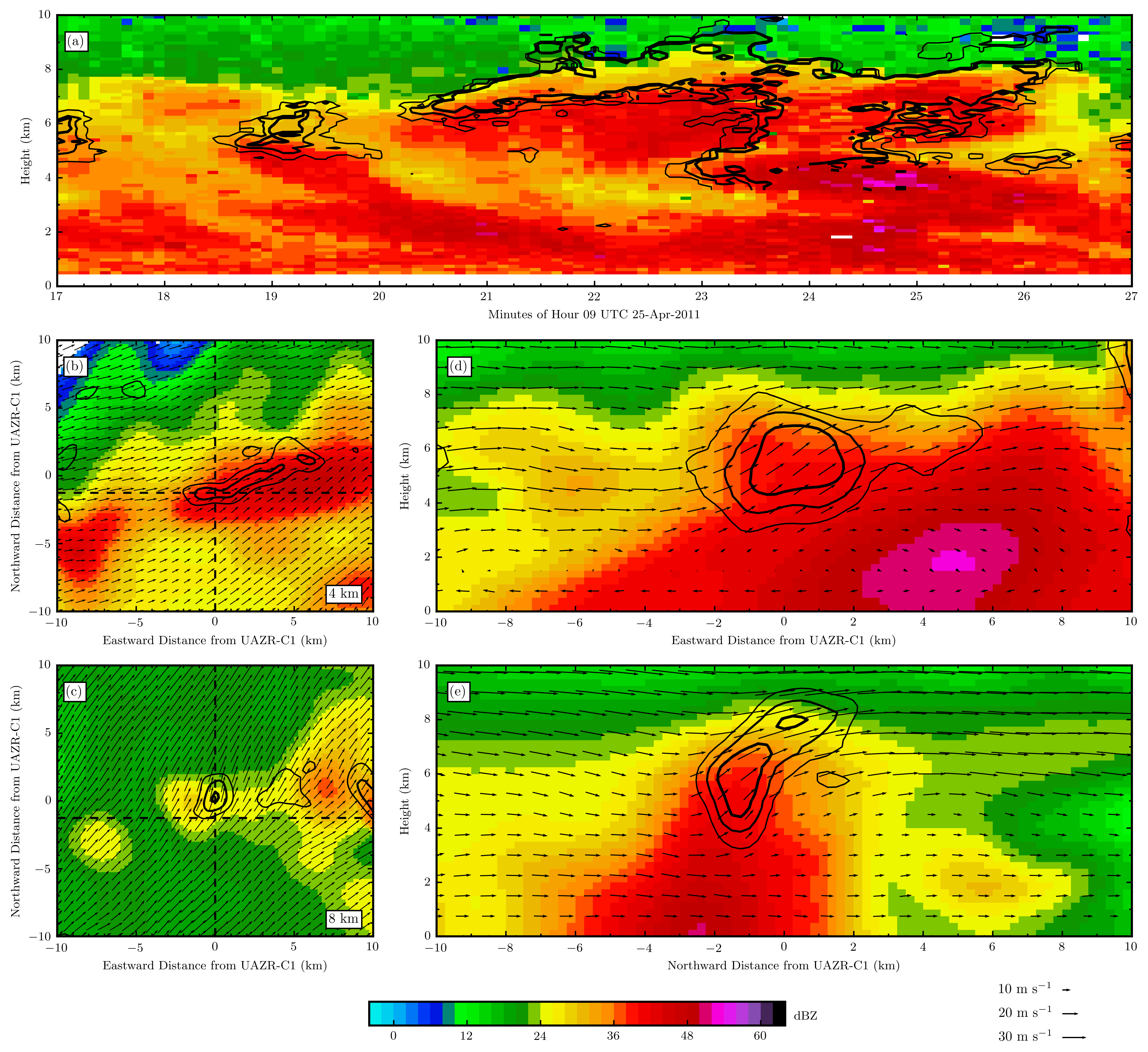
” The representation of deep convection and the parametrization of convective processes within cloud resolving to global climate model scales (CRMs and GCMs) is an ongoing challenge (Jakob 2010, DelGenio 2011). One explanation for the difficulties involved concerning the modeling of deep convection is the lack of deep convective observations, and specifically those to better constrain the connections between humidity, entrainment, and microphysical treatments within these models (Ferrier 1994, Milbrandt 2005, DelGenio 2012, Mrowiec 2012). To evaluate CRM deep convective treatments, one recommended path forward has been to exploit recent advances in aircraft and remote sensing capabilities to sample key process-scale properties including vertical velocity. […]
Radar wind field retrievals from networks of ground-based scanning Doppler radars may help to bridge the gaps and limitations in aircraft and profiling radar vertical velocity observational data sets. An advantage when using networks of scanning radars to retrieve the wind field (herein multi-Doppler wind retrievals) is in the potential for retrievals over larger areas (in better alignment with CRM domains, e.g., (Collis 2013)). Multi-Doppler wind retrievals capitalize on radar when estimating the two-dimensional Cartesian wind field at multiple atmospheric levels. The horizontal wind field solutions act as input to an algorithm that solves for the vertical wind component rather than estimating vertical air motion directly (Armijo 1969, Ray 1980, Laroche 1994, Protat 1999, Collis 2013). The solution assumes anelastic mass continuity, wherein this three-dimensional equation of motion is explicitly integrated contingent on a guess for the vertical velocity at the lower (e.g., bottom-up integration) or upper (e.g., top-down integration) boundary. We refer to this form of multi-Doppler radar wind retrieval method as iterative; a retrieval that does not satisfy all analysis constraints simultaneously (Bousquet1998). Although this iterative approach shares elements with three-dimensional variational techniques (3D-VAR, e.g., formally minimizing a global cost functional), non-simultaneously satisfying the analysis constraints may introduce suboptimal wind field solutions. […]
North, K. W., M. Oue, P. Kollias, S. E. Giangrande, S. M. Collis, and C. K. Potvin, 2017: Vertical air motion retrievals in deep convective clouds using the ARM scanning radar network in Oklahoma during MC3E. Atmospheric Measurement Techniques, 10, 2785-2806, DOI: 10.5194/amt-10-2785-2017.
Download these retrievals (most recent products)
Download these retrievals (evaluation products)
Shallow Cumulus Mass Flux
[…] For parameterizing shallow cloudiness and subsequently estimate thermodynamic fluxes, the bulk mass-flux based approach is very appealing since it embeds a cloud ensemble into a one-dimensional plume and represents turbulent transport using air density, draft magnitude and its fractional areal coverage [Tiedtke, 1989]. […] Physically, mass flux needs to reach zero at cloud top. Considering a situation where buoyancy and vertical velocity do not change, this calls for smaller (higher) detrainment (entrainment) rates for deeper cloud layers. Moreover, these rates should take into account the environmental conditions for example: In a humid environment, the entrained air and cloud mixture reach equilibrium quickly leading to less evaporative cooling and subsequently slower reduction of the mass flux with height [de Rooy and Siebesma, 2008]. […]
Marine cloud observations are sparse due to the difficulty to capture their undisturbed properties from steady land-based platforms. Past ship-based campaigns collected basic information over short periods about the atmospheric column and sea surface state (pressure, temperature, relative humidity and horizontal wind) as well as point measurement (from aircraft) of in-cloud properties during cumulus-topped boundary layer (e.g. BOMEX, 1969 [Holland and Rasmusson, 1973] and ATEX, 1969 [Stevens et al., 2001]). These short campaigns lacked the vertical information required to characterize the depth and dynamics of the shallow cumulus. […]
modeling studies would benefit from robust, long-term observations of cloudiness and mass flux. Fortunately, the recently established island-based observing facilities at Azores and Barbados are equipped with state-of-the-art remote sensors and thus, such observational datasets are within reach. […] In this study, we seek to further document the vertical and temporal variability of the Barbados trade-wind cumulus cloudiness and dynamics (e.g. up/down draft organization, velocity, areal coverage and mass flux). In addition, we aim to investigate how cloudiness and mass flux relate to boundary layer thermodynamic structure. […] “
Lamer, K., Kollias, P., & Nuijens, L. 2015. Observations of the Variability of Shallow Trade‐Wind Cumulus Cloudiness and Mass Flux. Journal of Geophysical Research: Atmospheres.


Addressing Uncertainties in Retrievals
The vertical motions in deep convective clouds regulate precipitation amount, intensity, and associated cloudiness. Multi-Doppler radar networks have been used to probe convection and provide wind retrievals including vertical air motion estimates. While there is a plethora of studies illustrating the ability of multi-Doppler radar observations to capture the wind divergence and circulation, there is little to show regarding the capability of the radar observing system to capture the upper level convective dynamics. This study addressed potential observational sources of errors in multi-Doppler radar updraft retrievals and updraft property estimates for deep convective clouds.
The impacts of the selected radar volume coverage pattern (VCP), the sampling time for the VCP, the number of radars used, and the added value of advection correction on the retrieval of the vertical air motion in the upper part of convective clouds are examined using the Weather Research and Forecasting model simulation, the Cloud Resolving Model Radar SIMulator (https://you.stonybrook.edu/radar/research/radar-simulators/), and a three-dimensional variational multi-Doppler radar retrieval technique. The findings are: 1) the VCP elevation strategy and sampling time have a significant effect on the retrieved updraft properties above 6 km altitude; 2) 2-min or shorter VCPs have small impacts on the retrievals; 3) increasing the density of elevations angles in VCP appears to be more effective to reduce the uncertainty than an addition of data from one more radar, if the VCP is performed in 2 minutes; and 4) the application of an advection correction to the 2-min VCPs can effectively improve the updraft retrievals, but for longer VCP sampling periods (5 min) the value of advection correction is challenging. Overall the experiments suggest that the use of rapid-scan radars can substantially improve the quality of wind retrievals if conducted in a limited spatial domain.
The present study suggests that the multi-Doppler radar techniques need to be carefully used to evaluate cloud resolving model simulations considering the limitations of the radar observing system. The present analysis can give valuable information to improve the observation strategies and decide optimized scan strategies for the on-going and future field campaigns targeting deep convection.
Oue, M., P. Kollias, A. Shapiro, A. Tatarevic, and T. Matsui, 2019: Investigation of observational error sources in multi-Doppler-radar three-dimensional variational vertical air motion retrievals, Atmos. Meas. Tech., 12, 1999-2018, https://doi.org/10.5194/amt-12-1999-2019.
